

As a tributary of the larger Missouri River, the Milk River begins near Browning, Montana, home of the nearby Blackfeet Indian Reservation, before angling northeast into international waters by way of Alberta, Canada.
The Milk River is unique among bodies of water in its return to the state of Montana, entering prairies and providing numerous recreational landscapes before ending near Fort Peck, Montana.
The Milk River – A Complete Guide
- History of the Milk River
- Geography & Stats
- Activities & Attractions
- Milk River Facts
- FAQ’s
- Conclusion
History of the Milk River

Previously indigenous land roamed by the Hidatsa tribes, the first known European contact with Milk River came through the 1805 travel journals of Merriweather Lewis of Lewis & Clark fame.
His journal states: “… the water of this river possesses a peculiar whiteness, being about the color of a cup of tea with the admixture of a tablespoon full of milk.” Due to its milky hue and consistency, Lewis and his fellow intrepid travelers came to the Milk River moniker.
However, the Hidatsa tribe had shared a different name for this lengthy and replenishing body of water: “the River that scolds all others”.
Why scold? The Hidatsa never gave Lewis a reason for their enigmatic naming convention (transliterated: Ah-mah-tah, ru-shush-sher), but Lewis noted it just the same.
So, what’s the real reason behind the milky name? Historians and geologists have explained that the milky, whitish appearance comes from a mixture of clay, silts, shale, and sand, all passing through the middle reaches of the water.
These same elements really come to life after a heavy rain, something Merriweather Lewis may have been privy to.
Geography & Stats
The Milk River is formed 21 miles north of Browning, Montana through the junction of its South and Middle Forks.
Both the 30-mile long South Fork and the 20-mile long Middle Fork rise in the Rocky Mountains east of the beautiful Glacier National Park.
Acting as a sacred site for indigenous people, both also rise in the Blackfeet Indian Reservation near Browning, while the North Fork diverts from the St. Mary River.
From there, the river’s mainstream flows east-northeast in southern Alberta, where the North Fork rejoins the party.
Flowing past the aptly-named town of Milk River and the Writing-on-Stone Provincial Park, the body of water makes its unique international turn into the Lower 48. Curveball!
Once home in Montana, the Milk River runs east past the picturesque Sweetgrass Hills, the low mountains of Whitlash, Montana, before heading south through the Fresno Dam – a popular recreation spot for fishing and swimming.
Once through the irrigation powerhouse dam, it heads east past Havre towards the northern side of the Fort Belknap Indian Reservation.
From here, the river traverses along prairies and Big Sky Country. Once near Malta, it turns north and then southeast, streaming past Glasgow until it finally reaches the Missouri River near the Fort Peck Dam.
Yes, that’s over 700 miles of adventure before emptying into the Missouri!
All along the way, locals and travelers alike can find numerous opportunities for recreation and relaxation, as well as sustenance. That’s one long tributary!
Activities & Attractions
Attractions
Milk River Observation Point
Named as a historic site on the Lewis and Clark National Historic Trail, the Milk River Observation Point was noted by fellow traveler Private Joseph Whitehouse as a dining place for those on the historic Lewis and Clark Trail.
And who wouldn’t want to dine here? Right at the confluence of the Milk and Missouri Rivers near Fort Peck Indian Reservation, this spot emanates natural beauty – jagged rocks, milky waters, grassy hills and plains.
The location is cited in several 1805 Lewis and Clark journal entries, Lewis specifically mentioned climbing a tall bluff to see where two rivers merge.
As you look around, notice the fast-moving waters, take in the bountiful cottonwoods, and drink in the crisp Big Sky air.
Got a dinosaur lover in the pack? The Hell Creek formation especially provides significant information on dinosaur life in the area – from triceratops to hadrosaurs and beyond.
And if you’re into exploring indigenous history, the Milk River Observation Point provides an immense opportunity to view the land as seen by Assiniboine Indians – natives that Lewis and Clark had no desire to disturb.
Lastly, if you look far enough into the distance, you may see people fishing on their own or with their loved ones. (More on that later!)
Trafton Trail & Trafton Park
Whether on a road trip or a proud Malta local, the cottonwood-dense Trafton Trail offers an exciting opportunity to stretch your legs – but more than that, it’s great for hiking, mountain biking, and camping.
This short trail around the Milk River takes around 30 minutes to complete and ends in the historic district of beautiful Malta. (It’s perfect for families!)
Things you may notice on the trail? Rabbits, singing birds, and – of course – whitetail deer.
If you’re more interested in overnight camping, Trafton Park offers a relaxing atmosphere to hit the hay under the cottonwoods.
Feel free to wake up in the morning and pick a cozy, lush fishing spot before moving on to the next leg of your adventure (don’t forget about the basketball courts, playground equipment, and softball fields!).
Tent and trailer sites are available for a $3 fee.
Hinsdale Milk River Park
Find yourself in Hinsdale? Lucky you! This unincorporated area may not get a lot of foot traffic, but it’s a must-see stop on your travels, providing some of the most spectacular badland views in all of Montana.
Besides being a sacred home to indigenous people before Europeans arrived, Hinsdale offers plenty of bird watching opportunities for the bird geeks – we know you’re out there!
But perhaps even more important to Hinsdale residents and travelers: Hinsdale Milk River Park. While Hinsdale has three city parks to choose from, the Milk River Park offers boating, fishing, water sports, and picnicking areas.
Welcome to cowboy country!
Bowdoin National Wildlife Refuge
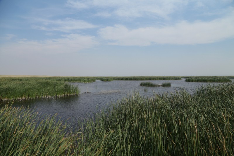
Established in 1936 as a wildlife refuge, the wide open skies of the Bowdoin National Wildlife Refuge sit right in the Milk River Valley – and as such, the Milk River acts as its main water source.
Home to 200 birds and a multitude of prairie wildlife, this immense ecosystem boasts 15,551 acres of natural surroundings – from wetlands to prairies to hiking trails.
More interested in a self-guided tour? The folks at Bowdoin National Wildlife Refuge offer a 15-mile auto tour to bring you face to face with antelopes, coyotes, and an abundance of waterfowl.
Writing-on-Stone Provincial Park
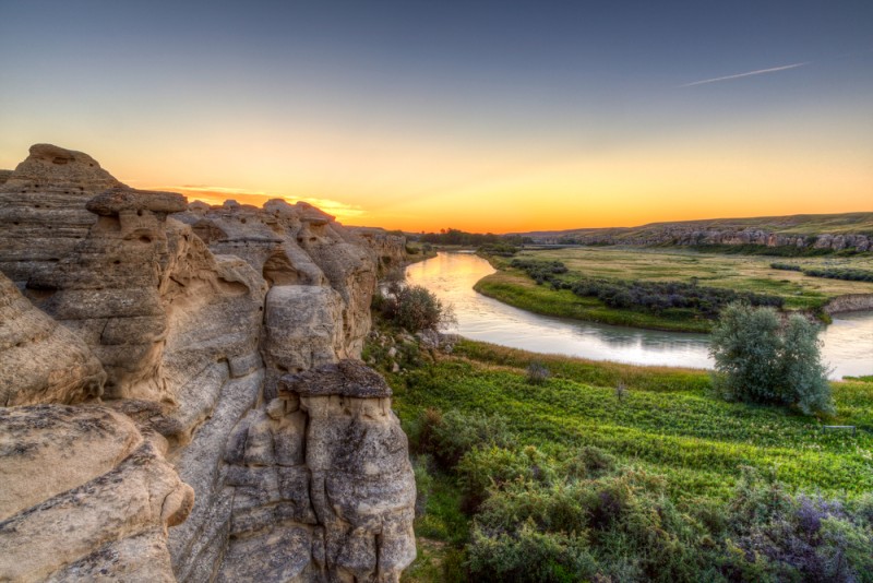
While not in Montana, this list wouldn’t be complete without mentioning the Alberta Writing-on-Stone Provincial Park (or Áísínai’pi), which shares this milky water source with Montana.
Sure, it may seem like the middle of nowhere, but this monumental Canadian badlands spot used to be home to numerous indigenous tribes, made obvious by their unique sandstone petroglyphs, or rock carvings.
This Milk River Valley area is sacred and meaningful for Blackfeet indigenous peoples – a place where many